
[Click here for the previous day]
I woke up late at 9am. This was possibly the last day I could sleep in, so I took advantage of it. I finished driving to the spot where Bob Spirko started his ascent. Driving around a bit to try to hide my SUV, and keep it relatively flat. There was no spot that did this, so I left it next to the road.
I started up over the col at the end of the road, and back down the other side. It was a bit windy at this point which wasn't making me too happy, but it was sunny and warm enough. My second source of info for this hike, Stav is Lost went over the intervening ridge farther along the road. Which put him closer to the ascent slopes after descending. It might actually be easier, but its debatable.

The view of Spirit Mountain once your over the first, of many ends of ridges on the way to the base of the peak. Though it looks like there is only one more end of a ridge left to go over, it was actually several, before I was down in the wash below the peak. There was much cacti dodging during this section. A theme of the desert. You do not bush-wack (because you cannot wack desert plants), you simply dodge cacti as best you can. I never managed to perfect it I guess, since I got stabbed several times on this hike.
I started up the correct slope to start my ascent, but couldn't find any cairns until I was basically up near the pinnacle, which is at the lower right in this photo. You ascend to the right of it, then pass behind it through a notch to start up. From there the trail is more easy to follow.

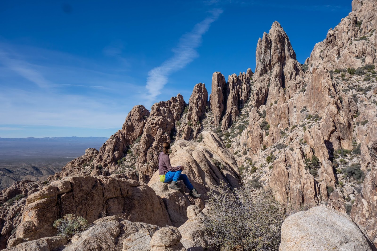
At the notch I took my first break, and ate a granola bar while pondering the upper mountain. The trail continued along the base of the wall on the left, then it crosses a gully coming off the mountain. After it ascends, then follows a low ridge on the other side.

On this low ridge, the trail was easy to follow and required not much in the way of scrambling, until about half way up.

There I reached a smooth rock slab section. I knew it was the trail because my viewranger app told me I was on the track I'd downloaded from Spirko. There was also several cairns on points higher up the slab. This ended up being the first (and harder) of the two sections that are Class 3 instead of Class 2 (in my opinion). On this slabby section the cairns indicate you can traverse climbers right, or ascend up straight (and slightly left).
It wasn't necessarily exposed. As there was a small ledge, and a prickly desert tree, you would fall on if you slipped off. The tree unlike a Rockies tree, would most likely hold your weight, and you would not fall farther. Though you would be a pincushion of thorns.
Still the slab didn't appeal to me, and I paced beneath it looking for another route for several minutes. Finally I committed and made it up, but this section worried me for the rest of the ascent until I'd successfully down climbed it.
In my defense of putting myself in this position: my first source on this peak Bob Spirko didn't have any photos of this section. My second local source Stav is Lost doesn't mention it either, though he does mention the second Class 3 part. Which makes me wonder if I didn't miss a work around. But it would be pretty far off the trail which I was on. Only Sonny Bou has pictures of it. However I had not looked at his report when I chose to drive down here in the casino, the afternoon before.

After that it was easier again. This is looking back down before I made another left turn on the trail to cross another gully. That gully then leads up to the ridge. You follow along the climbers right of the ridge, then ascent to the col between the western (true) and eastern summits.

From there a wall of rocks block your way to the true summit. The route goes through a cleft in the rock, to the right out of view. This is the second (easier) Class 3 section. Thankfully it was easier on this closer side and harder on the other side. Or rather you down climb the harder section it on the way to the summit. Which I actually prefer. Because climbing up is easier, so doing that on the way back is less stressful. Then its a short easy scramble to the summit. This photo is on the summit looking back over at the ridge and the eastern summit. The cleft in the rock is visible below.

The view from the lower eastern summit over to Lake Mohave to the east.

Looking down the slabby section on descent. This is a view down the straight route (rather than using a traversing route it looks like Sonny did). You can see the prickly tree and bush that would break your fall. It was much easier than I expected (as usual) and I was down in no time.
Then I took another break now that the hard part was done. Then continued down taking another break at the notch. I followed the trail down from the notch as it descended into the wash. I followed it for a short ways, until it disappeared. There was a faint traversing trail which started in the same area. Very very faint. I followed that over the next few ridges until I lost it. Then continued traversing over the seemingly endless ridge ends, until I was below the col. Which I stubbornly marched up. That part was rather less fun, and involved a lot of cacti dodging. Back at the car I celebrated that it still had all its windows.
I then set off back to Las Vegas, and experienced some bad traffic getting off the 95 onto the 215. I am always even more careful than normal in traffic down in the states. The last thing I want is to get into an accident. I drove around the 215 to my favorite wine and beer store next to the REI, and bought Heath his collection of beer. Then off to Lovell Canyon for the night. It was nearing dark when I got there, so there was no need to find a nice spot. I ended up using the same one I had last year.
Day 5 - December 27 (Thursday)
I got up at 7:30am. On this day I wanted to do the short scramble up Kraft Mountain, then start my drive back up the I-15.

I stopped ass I drove past Mount Wilson, as the sky was quite pretty, to take this photo. Its too bad there wasn't enough daylight to really complete an ascent of this peak. As well I was feeling a bit off about scrambling. Considering how well I'd handled any difficulties I'd encountered down here already. I wasn't taking any changes. On such a long ascent I couldn't fuss around like I had been doing, when things got difficult.
As I passed the Red Rocks Canyon Parkway entrance there were some cars parked outside of it waiting to get in. It was just after 8am, and the gates were still locked. The parkway is supposed to open at 6am during the Nov-Feb season, so it was concerning it was late. It appears that despite assurances things would run as normal on the website, they no longer were by this time. I was glad I hadn't set my heart on Bridge Mountain, as my route would have required me to get into the park right at 6am sharp.

Once in Calico Basin I parked and cooked up my oatmeal and coffee and contemplated Kraft Mountain with some trepidation. It looked cliffy, complicated and steep. I was using Bob Spirko's route which is now cairned and often used.
Starting out from the parking lot you have almost no approach. From the bouldering area, the route goes up the slope of rubble to the cliffs. Then follows a ledge for a short while, until it ends (more or less). At that point there is a gully coming down from the ridge that you scramble up.

The start of the ledge. Its a very wide ledge as you can see. There was nothing scary about this part.

After an initial harder step the rest of this gully was easy. It was fun scrambling.

At the top of the gully the route splits. I went right onto the east ridge, as did Spirko. However there is a more heavily cairned route that heads left out of sight and continues up in that direction. Meeting the east ridge after its major difficulties. I have no idea if its easier or harder.

The east ridge was initially easy. Weaving back and forth to avoid scrambling, and a few easy steps of scrambling. Then there were two harder section. The first one was the harder the one. It was on climbers left of the ridge. I found a way to avoid it on descent by going through the tunnel Bob Spirko found, which is on climbers right of the ridge. Around a corner, where it can't be seen until the last minute. This is the second harder section. I both ascended and descended this scramble. It was fun and not exposed, as it was sort of in a little chimney.

After some more scrambling and route finding I eventually got onto the summit ridge. I was on the far side from where the actual summit was. I initially kept to the right (north) side of the ridge. Then in the middle section kept to the left (south) side. Then descended to a low point on the ridge, before the final climb to the true summit. This seemed to be what most people did. This photo after I've completed the fist part of the traverse to the summit.

On the summit looking towards Turtlehead Peak, which I'd ascended a few days before. I'd thought I'd seen people on the summit as I scrambled along the ridge, but they were gone when I got to it. There is a more direct route to the summit scrambling up another (according to Spriko, harder) gully just to the south of it. As well as several other routes on other sides of the peak. The people I saw must have used one of those.

Seriously those boulders. This shows the scramble back up from the low point to the center ridge section.

A lovely spot for a photo. As it shows all the wonderful boulders of Kraft Mountain as well as some of the walls of Red Rocks Canyon. The one in the light in center is Bridge Mountain.

The tunnel which can be used to avoid one of the harder moves on this route. It is much easier to find on descent actually.

An easy scramble section on the descent. Which I decided to climb back up again to get an action shot. Never get those naturally when your by yourself.

It was pretty easy to reverse my route down, despite the maze of boulders on the ridge. I then easily found the gully, which was easy to descend down to the very last step, shown here.

Then across the ledge, and down the rubble slope. This photo is at the base of the peak. In the Kraft boulders. Where I found a ton of people! While I had been alone on the scramble itself. Bouldering apparently, is a very popular activity in Vegas. I couldn't believe how many people were out here now. And even more were hiking in, as I hiked back to my car. I had to step off the trail several times to avoid people with crash pads on their backs.
Once back at the car I went back to Red Rocks Casino, and sat on the edge of a water feature to check the weather. I needed the free casino wifi. It looked very cold up in Utah, but I left and started my drive up there anyway. Instead of using my originally planned campsite to access Bryce Canyon first thing in the morning though, I stopped back at the National Forest just north of St. George which is accessed through the town of Leeds.
Even there it was too cold for the poor jet boil to get my pasta and bison chili to boil. So I settled for a slow cook of about 30 minutes, then gave up and ate it. It was indeed cooked, but it left me with little desire to try to cook in these temperatures again.
[Click here for the next day]
No comments:
Post a Comment