Sunday 17 February 2019

Day 6 - December 28 (Friday)

[Click here for the previous day]

I woke up at about 5:15am and drove off. Soon into a mild snowfall. In Cedar City, after filling up up gas, I turned off onto a side road which would take me east towards Bryce National Park. The road was snow covered most of the way. Some drifts were actually quite bad, and I wouldn't want to have driven this in just a little car.  It was very slow going. Eventually I got onto the 89, and it was in better condition. Then onto Bryce.

Extremely disappointingly, the government shut down was still ongoing. Bryce was still open, but due to having no paid workers they didn't have as much plowed and open as they normally would in the winter. The road was shut down past sunset point. I had planned to stop at these, and Inspiration and Bryce Points, to take photos. Before doing a hike farther south along the road. That plan went out the window of course. 

Getting out of the car at sunset point, I just left with my full winter clothing on, but no backpack, just my camera in my jacket pocket. Thinking to just take some photos, then consider my options. As usually happens with me, I got sucked into hiking all the way along the rim trail to Bryce Point. I thankfully was wearing my icers, but I stupidly didn't have any food or water with me. Nor did I have my tripod. 


Views from the rim trail near Sunset Point.

The trail was technically closed just before Inspiration Point, but many people were hiking up to that viewpoint. 


Views at Inspiration Point. Its hard to convey the vast proportions of the views from each of these points. So I attempted to stitch panoramas together. The photo quality goes down, but it gives a better idea of what you can see in real life. 

Almost no one was continuing on the Rim Trail past Inspiration Point. I wasn't concerned about conditions though. The trail was only under a foot or so of snow, and not icy. Though it was exposed on one side down to the canyon. It stayed away from that edge by a fair margin, and therefore was perfectly safe in my opinion for me to hike by myself in my icers. Another factor in my continuing on, was that no one was around to see me do so, and therefore follow me even though they most likely shouldn't. I never want to entice any people less well equipped, and less used to these conditions to follow me.


This was the most exposed section of the trail, where it becomes a bit narrow and you are hiking right next to the canyon drop off on the left hand side. It is right after Inspiration point. It was still easy, and after this the rest was far less exposed. The trail was usually a placed a bit back from the canyon edge in the trees. Coming out at corners, so you could see the view.

The views along the canyon trail were varied and amazing. I ended up being quite happy that instead of doing my original plan, I was forced to hike this instead. Just visiting the viewpoints is great, but seeing them all lined together by hiking along the Rim Trail, was definitely better. 


Views along the Rim Trail.


A giant window in the lighter formations to the left, above the darker formations down in the canyon below.


At the far end at Bryce Point a cold wind was blowing up from the valley, so despite how lovely it was there I couldn't stay long.


More views from Bryce Point. A truly spectacular spot. Which I had all to myself (this must be extremely rare), on this cold December day. I would expect hordes of crowds here in the summer. 


A tree helped me take this photo (since I didn't have my tripod), on the way back along the Rim Trail.


Back at Sunset Point after hiking the Rim Trail. 

I had some food, then actually packed up a bag to do a short hike down into the canyon. I originally didn't plan on going that far, so I didn't look at the map all that carefully. But once again I couldn't stop myself, and ended up hiking the entire Navajo / Queens Garden loop. Which returns you up to Sunrise Point, then you walk the Rim Trail from there back to Sunset Point. It was a lovely little loop, and again I'm glad I did it.


Starting down the Navajo Trail you first reach Thor's Hammer. 


Then the trail descends switchbacks between two giant walls of cliffs. This reminded me slightly of the switchbacks going up to Angels Landing the year before in Zion. Then there are some natural bridges, hidden around a corner at the end. After which your out into the open bottom of the canyon. The Navajo Loop would continue back up to the Rim to the right. This part of the trail was closed though, and with the number of people around I respected the closure, and instead continued to the left. This led me along the bottom of the canyon to Queens Garden.


Queens Garden and its hoodoo formations.


Continuing along the Queens Garden trail. This photo is staged, as I am facing the opposite direction I hiked. There were so many colorful hoodoo formations along this trail. As well as a few man made tunnels and other interesting features. It was so different from the Rim Trail, it was a great easy second hike for the day. My actual plan for this day probably wouldn't have been any better.


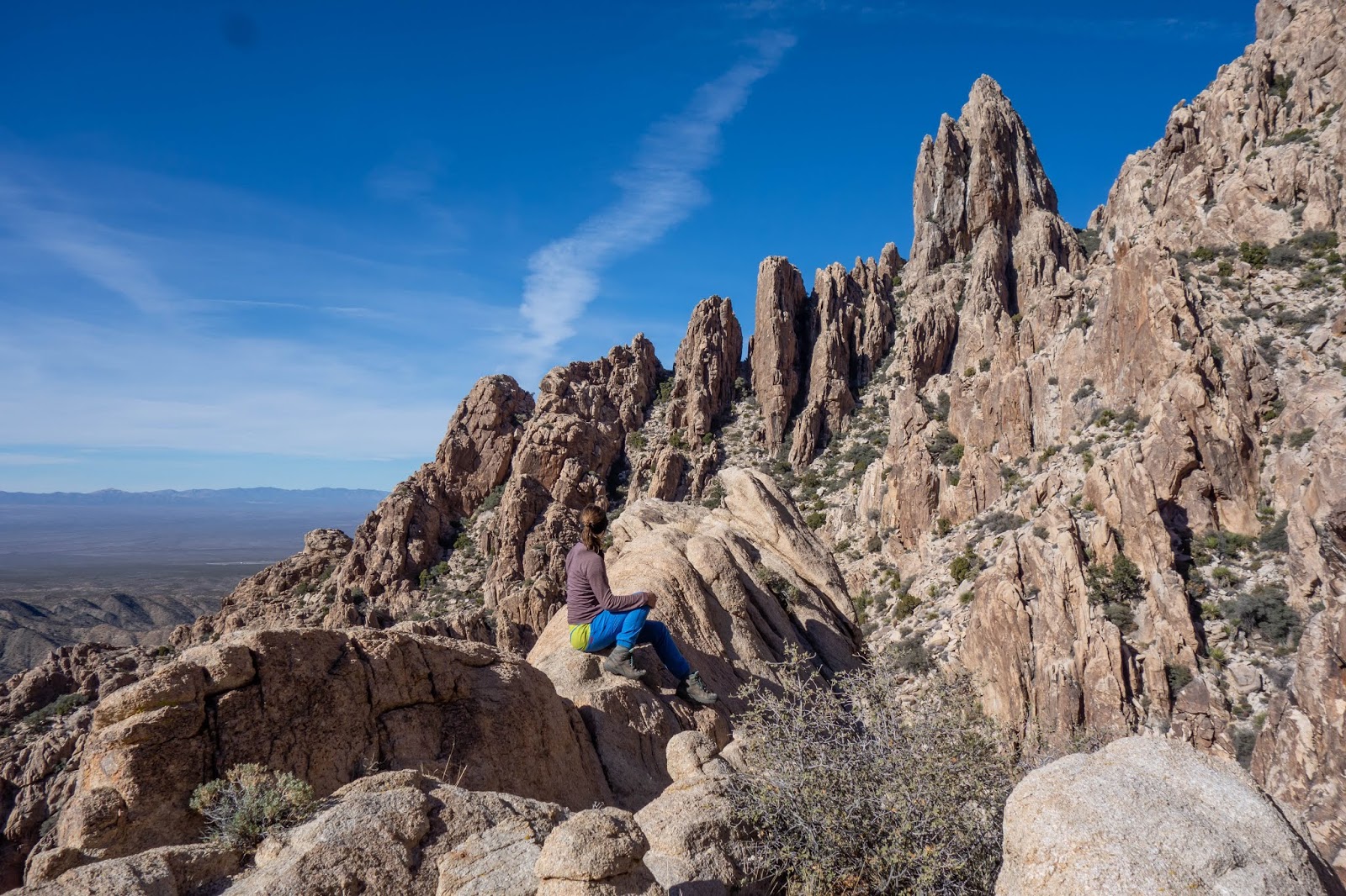
Near the end of the loop there is this precarious perch that makes a good photo opp. I can't recommend sitting here by any means, its quite the drop off on all sides, so be very careful if you try it. Especially in the snow. I was watching some other people pose here, and help them take photos, so I just couldn't resist getting one of my own though. 

After getting back to the car, I decided against waiting for sunset and drove off to my next stop of the day: Mystic Hot Springs. By the time I got there it was sunset. I had a lovely hot shower, which was a real treat. My hair was becoming quite the filthy mess by this point. Then I got into the hot springs after it had become dark. So I couldn't get any photos unfortunately. After relaxing for some time, and talking to a man from Ohio who had recently been to Banff, I had to get out. I still had to finish my drive up the 89 to a national forest spot near Fifth Water Hot Springs. So that I was close enough to hike in very early in the morning. 

I stopped at a KFC for dinner, then continued on. The drive was taxing, as the small towns it goes through seemed never ending. Eventually I got out onto the US-6 and found my parking area. I do love the National Forests in the USA. It was about -13°C when I went to bed. This was going to be my coldest night yet.


Day 7 - December 29 (Saturday)

I woke up at 3:45AM, cold. I got up and ran the far for ~5 minutes to fill it with warm air again, then got back into bed. After that I managed to sleep till 8am, though it was still a bit chilly in the end. I pulled the wool blanket I had been using to protect my feet from the truck, up over the sleeping bag. This seemed to help, rather than hinder (by decreasing the loft of my down sleeping bag). It was -15°C when I got up at 8am and drove off, eating some nuts and beef jerky in the car for breakfast, and doing without coffee. The trail head for Fifth Water Hot Springs is along the Diamond Fork Road. 

The whole time I was planning this trip, I'd wished there was a way I could have avoided doing Fifth Water Hot Springs on a Saturday. I knew it would be crowded despite it being winter, and despite the road being closed a full 6km from the regular trail head. The parking lot had a few cars, but wasn't full this early in the day. So I started off. The road portion was a bit boring. Eventually I got to the Three Forks trail head, and turned off onto the actual trail. This was more pleasant to walk along. Though I was extremely glad I brought my icers, as two sections of the trail were sheer ice and looked very dangerous without them.


Hiking along the trail, which follows Fifth Water Creek. Its a quite 4km and 238m up to the springs from the Three Forks trail head. It took my only 1h 10min to do the whole hike from the road closure.

When I got to the springs there were only three couples in the main area, and two of those were leaving. I couldn't believe my luck to have the place mainly to myself. One of the girls was nice enough to take some photos for me. She was extremely obliging, and even suggested I go up to the other pools to get more photos. I was very impressed with her patience. I would never have gotten any photos here otherwise.


The lower pool of the main area, which has a waterfall coming off the upper pools into it.


The upper green pool, which I sat in for the majority of the time I was here.


The upper blue pool, and a lot of little waterfalls leading into it.


A short panorama I stitched together of the upper pools of that main area. A truly lovely little spot to spend a chilly morning. 


There were some more pools (possibly hotter?) above the main area (shown here), though those were quite shallow from the looks of it, and not as large. As well, just below there was one last pool, though it couldn't possibly have been as hot.

After the two couples left, not too many people showed up for a full two hours. I sat alone in my pool (the deeper green one) enjoying the warmth and the natural beauty of the place. 


Then when more people showed up I got out, changed, and headed back out. It was basically right at the point that I'd been sitting still to long, and wanted to get out anyway. So that was perfect timing! There were a lot of people in the pools by the time I changed, and many more hiking up. I was extremely glad I'd planned this correctly, and gotten there bright and early.

I drove off down the US-6 which lead into Provo and got back onto the I-15. Stopped at the the Starbucks by the REI in Salt Lake City and then continued on. I ended up staying in Hawkins Reservoir again that night. The whole way it was a bit snowy and overcast, but the roads so far had been good.

I was restless that night and didn't sleep very well. Getting up around midnight and reading some more before finally settling down. 


Day 8 - December 30 (Sunday)

I woke up at 8am to continue driving back to Calgary. Originally I had planned to hike in a state park in Utah, but the cold temperatures were wearing me down. So instead I'd changed my mind, and decided to drive home early so I could spend New Years Eve with Heath.

As I passed Idaho Falls the road conditions deteriorated. It was a snow storm for most of the way back up to Calgary. It was sunny for a while around Butte, but really terrible going over Elk Pass beyond that. The wind was strong and the road was completely covered. Visibility was very low, and the steep descent was nerve wracking. I only arrived at Boulder at the bottom of that section at 3pm. 

I decided to take a break and see if the storm would wear itself out. Driving through town to Boulder Hot Springs. The lady at the desk helpfully looked up the weather for me, and said the main part of the storm would end around 8pm. I first went into the outdoor pool, but the wind was too strong, and it was too cold outside for that. So I went back into the indoor pools. These are connected to the change rooms, and therefore separate for women and men. There was also a cold plunge pool, and a steam room. I sat in the small square room containing the hot pool for a long time. Occasionally going outside for a moment to cool off. There wasn't much to see, but there was no one around and the hot water was relaxing as always. It was my own subterranean oasis. 

I eventually got out after two hours, and drove back to the gas station in Boulder. The woman behind the counter said she had been urging everyone who came in to stop driving and take a break. Conditions were just too bad. I set up my window covers, and took a nap where I was parked. 

I woke up at 8pm. I had been having nightmares about slipping around on the road and eventually crashing over the edge. Apparently the long drive was getting to me. I bought a coffee and started off again. At this point I'd run out of Mythos and stated a new audio book Heath had got for me: Sharp Objects. Which was a mystery novel. The characters were all very messed up. So it was a bit of a depressing listen, but interesting at least, and kept me awake. 

The road to Helena was still all downhill, which I cursed on my way down. Once there it became slightly easier. The next pass was also less stressful, and in some time I was at Great Falls. Some parts of the road at this point were basically dry, while others appeared and felt to be mainly covered in black ice. It was still rather slow going. I stopped at a rest area in the deep gully, and took another nap from 2am to 5:30am. Then continued on the next day to Calgary. Making it back in plenty of time to have New Years Eve dinner at a sushi restaurant, and then go to a party at Heath's cousins house.

Total distance for the trip 5315km.

Next time I plan on staying down longer, in case the roads are bad to make it more worth while. Also possibly not going at Christmas, so I don't have to endure backlash from my family. I may even go down to Arizona instead of Nevada. Though I still have Death Valley to see out in California, if I do Nevada again. Its 50/50 at this point. 

Day 4 - December 26 (Wednesday)

[Click here for the previous day]

I woke up late at 9am. This was possibly the last day I could sleep in, so I took advantage of it. I finished driving to the spot where Bob Spirko started his ascent. Driving around a bit to try to hide my SUV, and keep it relatively flat. There was no spot that did this, so I left it next to the road. 

I started up over the col at the end of the road, and back down the other side. It was a bit windy at this point which wasn't making me too happy, but it was sunny and warm enough. My second source of info for this hike, Stav is Lost went over the intervening ridge farther along the road. Which put him closer to the ascent slopes after descending. It might actually be easier, but its debatable. 


The view of Spirit Mountain once your over the first, of many ends of ridges on the way to the base of the peak. Though it looks like there is only one more end of a ridge left to go over, it was actually several, before I was down in the wash below the peak. There was much cacti dodging during this section. A theme of the desert. You do not bush-wack (because you cannot wack desert plants), you simply dodge cacti as best you can. I never managed to perfect it I guess, since I got stabbed several times on this hike.

I started up the correct slope to start my ascent, but couldn't find any cairns until I was basically up near the pinnacle, which is at the lower right in this photo. You ascend to the right of it, then pass behind it through a notch to start up. From there the trail is more easy to follow.


At the notch I took my first break, and ate a granola bar while pondering the upper mountain. The trail continued along the base of the wall on the left, then it crosses a gully coming off the mountain. After it ascends, then follows a low ridge on the other side.


On this low ridge, the trail was easy to follow and required not much in the way of scrambling, until about half way up. 


There I reached a smooth rock slab section. I knew it was the trail because my viewranger app told me I was on the track I'd downloaded from Spirko. There was also several cairns on points higher up the slab. This ended up being the first (and harder) of the two sections that are Class 3 instead of Class 2 (in my opinion). On this slabby section the cairns indicate you can traverse climbers right, or ascend up straight (and slightly left).

It wasn't necessarily exposed. As there was a small ledge, and a prickly desert tree, you would fall on if you slipped off. The tree unlike a Rockies tree, would most likely hold your weight, and you would not fall farther. Though you would be a pincushion of thorns.

Still the slab didn't appeal to me, and I paced beneath it looking for another route for several minutes. Finally I committed and made it up, but this section worried me for the rest of the ascent until I'd successfully down climbed it.


In my defense of putting myself in this position: my first source on this peak Bob Spirko didn't have any photos of this section. My second local source Stav is Lost doesn't mention it either, though he does mention the second Class 3 part. Which makes me wonder if I didn't miss a work around. But it would be pretty far off the trail which I was on. Only Sonny Bou has pictures of it. However I had not looked at his report when I chose to drive down here in the casino, the afternoon before. 


After that it was easier again. This is looking back down before I made another left turn on the trail to cross another gully. That gully then leads up to the ridge. You follow along the  climbers right of the ridge, then ascent to the col between the western (true) and eastern summits. 


From there a wall of rocks block your way to the true summit. The route goes through a cleft in the rock, to the right out of view. This is the second (easier) Class 3 section. Thankfully it was easier on this closer side and harder on the other side. Or rather you down climb the harder section it on the way to the summit. Which I actually prefer. Because climbing up is easier, so doing that on the way back is less stressful. Then its a short easy scramble to the summit. This photo is on the summit looking back over at the ridge and the eastern summit. The cleft in the rock is visible below.


The view from the lower eastern summit over to Lake Mohave to the east.


Looking down the slabby section on descent. This is a view down the straight route (rather than using a traversing route it looks like Sonny did). You can see the prickly tree and bush that would break your fall. It was much easier than I expected (as usual) and I was down in no time.


Then I took another break now that the hard part was done. Then continued down taking another break at the notch. I followed the trail down from the notch as it descended into the wash. I followed it for a short ways, until it disappeared. There was a faint traversing trail which started in the same area. Very very faint. I followed that over the next few ridges until I lost it. Then continued traversing over the seemingly endless ridge ends, until I was below the col. Which I stubbornly marched up. That part was rather less fun, and involved a lot of cacti dodging. Back at the car I celebrated that it still had all its windows.

I then set off back to Las Vegas, and experienced some bad traffic getting off the 95 onto the 215. I am always even more careful than normal in traffic down in the states. The last thing I want is to get into an accident. I drove around the 215 to my favorite wine and beer store next to the REI, and bought Heath his collection of beer. Then off to Lovell Canyon for the night. It was nearing dark when I got there, so there was no need to find a nice spot. I ended up using the same one I had last year.


Day 5 - December 27 (Thursday)

I got up at 7:30am. On this day I wanted to do the short scramble up Kraft Mountain, then start my drive back up the I-15. 


I stopped ass I drove past Mount Wilson, as the sky was quite pretty, to take this photo. Its too bad there wasn't enough daylight to really complete an ascent of this peak. As well I was feeling a bit off about scrambling. Considering how well I'd handled any difficulties I'd encountered down here already. I wasn't taking any changes. On such a long ascent I couldn't fuss around like I had been doing, when things got difficult. 

As I passed the Red Rocks Canyon Parkway entrance there were some cars parked outside of it waiting to get in. It was just after 8am, and the gates were still locked. The parkway is supposed to open at 6am during the Nov-Feb season, so it was concerning it was late. It appears that despite assurances things would run as normal on the website, they no longer were by this time. I was glad I hadn't set my heart on Bridge Mountain, as my route would have required me to get into the park right at 6am sharp. 


Once in Calico Basin I parked and cooked up my oatmeal and coffee and contemplated Kraft Mountain with some trepidation. It looked cliffy, complicated and steep. I was using Bob Spirko's route which is now cairned and often used. 

Starting out from the parking lot you have almost no approach. From the bouldering area, the route goes up the slope of rubble to the cliffs. Then follows a ledge for a short while, until it ends (more or less). At that point there is a gully coming down from the ridge that you scramble up.


The start of the ledge. Its a very wide ledge as you can see. There was nothing scary about this part.


After an initial harder step the rest of this gully was easy. It was fun scrambling. 


At the top of the gully the route splits. I went right onto the east ridge, as did Spirko. However there is a more heavily cairned route that heads left out of sight and continues up in that direction. Meeting the east ridge after its major difficulties. I have no idea if its easier or harder.


The east ridge was initially easy. Weaving back and forth to avoid scrambling, and a few easy steps of scrambling. Then there were two harder section. The first one was the harder the one. It was on climbers left of the ridge. I found a way to avoid it on descent by going through the tunnel Bob Spirko found, which is on climbers right of the ridge. Around a corner, where it can't be seen until the last minute. This is the second harder section. I both ascended and descended this scramble. It was fun and not exposed, as it was sort of in a little chimney.


After some more scrambling and route finding I eventually got onto the summit ridge. I was on the far side from where the actual summit was.  I initially kept to the right (north) side of the ridge. Then in the middle section kept to the left (south) side. Then descended to a low point on the ridge, before the final climb to the true summit. This seemed to be what most people did. This photo after I've completed the fist part of the traverse to the summit.


On the summit looking towards Turtlehead Peak, which I'd ascended a few days before. I'd thought I'd seen people on the summit as I scrambled along the ridge, but they were gone when I got to it. There is a more direct route to the summit scrambling up another (according to Spriko, harder) gully just to the south of it. As well as several other routes on other sides of the peak. The people I saw must have used one of those.


Seriously those boulders. This shows the scramble back up from the low point to the center ridge section.


A lovely spot for a photo. As it shows all the wonderful boulders of Kraft Mountain as well as some of the walls of Red Rocks Canyon. The one in the light in center is Bridge Mountain.


The tunnel which can be used to avoid one of the harder moves on this route. It is much easier to find on descent actually.


An easy scramble section on the descent. Which I decided to climb back up again to get an action shot. Never get those naturally when your by yourself.


It was pretty easy to reverse my route down, despite the maze of boulders on the ridge. I then easily found the gully, which was easy to descend down to the very last step, shown here.


Then across the ledge, and down the rubble slope. This photo is at the base of the peak. In the Kraft boulders. Where I found a ton of people! While I had been alone on the scramble itself. Bouldering apparently, is a very popular activity in Vegas. I couldn't believe how many people were out here now. And even more were hiking in, as I hiked back to my car. I had to step off the trail several times to avoid people with crash pads on their backs.

Once back at the car I went back to Red Rocks Casino, and sat on the edge of a water feature to check the weather. I needed the free casino wifi. It looked very cold up in Utah, but I left and started my drive up there anyway. Instead of using my originally planned campsite to access Bryce Canyon first thing in the morning though, I stopped back at the National Forest just north of St. George which is accessed through the town of Leeds. 

Even there it was too cold for the poor jet boil to get my pasta and bison chili to boil. So  I settled for a slow cook of about 30 minutes, then gave up and ate it. It was indeed cooked, but it left me with little desire to try to cook in these temperatures again. 

[Click here for the next day]

Saturday 16 February 2019

Southern Road Trip #2 - December 21 - 31, 2018

My laboratory shut down over the Christmas holiday season this year, forcing me to take vacation when I normally wouldn't. This meant I had 11 days off consecutively. While it was over Christmas, and some would say I should have spent it with my family. I couldn't sit around in the cold Rockies winter for 11 days straight. It was as great opportunity for me to take a second southern road trip. On my first I hadn't hiked nearly everything that you could around Las Vegas. I also had missed various other things on the way back up.

My goals were the same as last time. Spend zero dollars on accommodation. This time I succeed, despite temperatures down to -15 degrees Celsius that made me wish I could afford a hotel. Spend little on food. Which I succeed doing, only eating one restaurant meal and a few fast food stops. When the temperature became too cold for the poor, long suffering jet boil to handle. Climb as many peaks as I can, visit as many hot springs as I can find, and visit a new National Park. 

I was very successful. Only messing up one day that it rained/snowed in the morning, by doing an easy walk up a hill that can barely be counted as a peak. I did downgrade most of my hikes due to the snow that fell, and a lack of daylight during this time of year. I had more ambitious plans that I set aside. I also ended up going back a day early so as not to spend New Year Eve alone. Despite this I had a great time, and though I would have liked to spend more time in the amazing canyons of Red Rocks, it was otherwise successful. 

I had to make some adjustments to my sleep set up this time, in anticipation of the colder temperatures I would experience. I bought a large sheet of 1.5 inch Polyisocyanurate Insulated Sheathing, and cut it to fit my sleeping area. This wasted a lot of the giant sheet, but I kept it in storage for later. I taped up the edges with waterproof duct tape (it was shedding horribly), and that became the platform my sleeping pad rested on. This worked wonderfully. The cold air which circulates under the car and was getting through my sleeping pad last time to attack me, couldn't this time. 

I also bought a sleeping bag liner from Sea to Summit (in a local Calgary store). This is supposed to increase warmth by up to 15°C. Using it I could sleep mostly comfortably down to about -10°C when I could only do -4°C before. I also managed to survive a -15°C night. I did have to restart the car half way through my 8 hour sleep, to re-fill it with warm air though. But two 4 hour naps isn't a bad sleep at -15°C in just your unheated SUV. 

Lastly I bought an actual front windshield cover for the inside of my car. This way all the windows would be properly covered. I still set up an extra towel across the front seat gap, to blot out the blinking light on my dash board. The actual cover made me feel far more secure in the car though, since there was no possible way to see inside now at all. My fancy covers I made last time (see the end of this post) were still in great shape. I've used them all summer, and am still in love with them.


Day 1 - December 22 (Saturday)

This time I made it to the real Lava Hot Springs (see last trip when I ended up in the hotels hot springs). I was a bit gittery from drinking way too much coffee on the way down, but otherwise enjoyed their various pools of many temperatures. I then drove back down the side road to Hawkins Reservoir and spent a night there. I learned from my last trip, and instead of keeping the towel and bikini in the car with me, I instead had it outside. I rolled down the drivers window, placed the bag outside but the straps of it inside, then rolled the window back up again. This way it wasn't sitting on the ground beside the car or anything, and the bag at least was secured to the car but outside.


Day 2 - December 23 (Sunday)

I had found a lovely natural hot springs just off the I-15 during my research this time. I have no idea how I didn't find this before. Its an absolute gem. Its on private land, but currently the land owner allows access to several pools of hot water. Called Meadow Hot Springs, it is just outside the town of Meadow, and only a ~5 minute drive off the main highway.

I got there decently early at ~10am. There were a few vehicles parked there with people sleeping inside. They sort of got up when I got there, but I still managed to take a few pics before they got into the springs. 


This is the hottest pool. Its extremely deep in the center, to the point that some of the people who came in later scuba-dived down into it. Which was neat to see. Apparently this is the pool to be in at night. At times it can be almost completely full. People bring glow sticks, and throw them down to the bottom to light up the pool. Divers like the ones I saw, pick these up when they go down, to help clean up the place and keep it open for future visitors. So a big thanks to those people. Leaving no trace is as important on private land, as it is on public.


I sat in this pool for probably a full two hours. Usually on the edge where you can lean against the it. Sitting on this rope across the deepest section was a bit unnerving. At one point I got out and got my jet boil from the car. I then got back in and cooked up and ate a second breakfast of oatmeal poolside. A luxury not afforded to you in commercial hot springs. I was very careful not to spill any in the pool or along the edge.


I was just about to leave, when I decided to go check out the smaller shallower pool off in the distance. This pool is also much less hot. Almost to the point that you cannot sit in it during these cold winter months. However it was slightly more picturesque. 


So I couldn't help taking another photo. Then some more people showed up and I decided it was time to finish my long drive down to Las Vegas. It was getting late after all.

I had vague hopes that it wouldn't be too snowy, and I could hike Bonanza Peak up in the northern high Spring Mountains. I did end up getting all the way up to the the chilly parking lot. Which is above the small town of Cold Creek, and far below that the prisons along the highway below that. The parking lot was an ice sheet, and after cooking up my dinner I'd lost my appetite for the hike. While I was pretty sure I could make it up the peak. I hadn't driven for 19 hours down to the Las Vegas area, to hike up a snow covered trail in my icers. I was here for warmth and dry rock.

So I drove down to a small parking area below Cold Creek (and the snow line), and spent the night in the SUV there.


Day 3 - December 24 (Monday)

I woke up to sunrise poking its light through a small gap in my window covers. I could just somehow tell it wasn't the moonlight anymore. It had a different quality. The moon was full during the first few days of this trip, and extremely bright at night.

I finished my drive back down to the highway and around Las Vegas to Red Rocks Canyon. Seeing some burrios along the way down the road. 


The view from my parking area.


The burrio in the morning sunshine.

The gate was open but not manned, since this was during the beginning of the government shut down. It had started the day I left, and I'd had to quickly check some websites in Lethbridge on my way down, to ensure I even could get into this state park and Bryce. If I couldn't the trip would probably have been off. But thankfully both websites reassured me they would stay open (even if not fully). 

I drove over to the Turtlehead Peak trail head parking lot, and cooked up some breakfast and coffee. I ate as I packed for this short hike. Soon as I made my way up towards the peak on the official trail temperatures were reaching +15°C. A heat I haven't hiked in since August. It was blissful, but I was sweating like crazy. 


The trail was initially easy to follow but started braiding once it got into the shallow gully below Turtlehead Peak. 


After a small mistake where I went too high, I found the correct path again and followed it up to the ridge-line. As you can see some parts are marked with painted rocks to help.


On the ridge-line there is a single trail again, until you get around to the backside of the Turtle. Then it braids again, but no way is wrong as you make your way up to the summit.


The views looking over the Calico Basin area (outside of the state park), towards Las Vegas. Below me here in the center is Kraft Peak, a really fun scramble I'd complete on my last day in Las Vegas.


The view south along the peaks and canyons of Red Rocks Canyon is also very nice. Despite some thin cloud on this day. As you can see the highest points behind the Red Rocks peaks already is covered in snow. Just above my head to the left is Bridge Mountain. A long day I'd hoped to complete the next day. The weather had other plans for me though.

On the top I talked briefly with some rock climbers out for a day of cardio. They couldn't understand why I said I was too lazy to learn how to use ropes and start rock climbing, when I was obviously not too lazy to drive all the way from Calgary to Las Vegas. They sort of teased me over it, and it felt just like home (many people tell me I am just too easy to tease). 

Back at the trail head, it was still quite early so I decided to do the hike into Icebox Canyon. The road was crazy busy at this time of day, but I somehow managed to get a parking spot at the trail head.


I was so happy about that I started out not properly packing my super small backpack. I had a sweater, water, camera, passport, but had forgotten to take any food. Since this hike was only supposed to take 1-2 hours I figured I'd live.


The official trail ends only a small ways into the canyon. Its hard to tell where, but once you descend down into the wash you know your off the trail. I continued along (as most people do), down the canyon. It was extremely easy, nothing like Pine Creek Canyon. Only two places where you do a little scramble. Then one spot where you must leave the wash, and go up on the side into the shrubbery, to avoid a step. 

Along the way I met a girl who had been travelling around for two months in the southwest solo. Who was nice enough to take the above photo of me at the end of the canyon. She continued up the steep rocky slope to the left of the watercourse in this photo, to the pool at the very back of the canyon. And I stupidly followed her. 


It was certainly neat being up there, but as I watched her slide back down the slick rock, I suddenly realized it was quite terrifying to get down. The slope we'd climbed up was a bit featureless for a scramble. And tilted ever so slightly toward the water course, and a certain broken leg if you feel down there.  I stood at the top for some time contemplating my stupidly. The girl thankfully did not leave me (she was very nice and this was not her fault at all), and tried to convince me it was fine from the bottom. 

Soon more people showed up, and one older man climbed a bit of the way up the lower part which was more featured. With him pushing me feet into the small features / smears in the rock, I shakily down climbed the feature facing inwards. Rather than slithering down like the girl had. As several other hikers look on. An ignoble end to my first day in Red Rocks, and probably another reason I backed down on doing longer hikes the next few days (as well as the weather).

After that I drove back out of the park and into Lovell Canyon. I passed my old campsite from the year before, and continued down the road farther. Eventually going up a side road which led to a spot that had amazing views towards Mount Charleston. 


The sun was still out and it was actually warm. So I spent some time digging into a smoked salmon, one of my employees had given me for Christmas. It was great. I also had a favorite american beer. A raspberry sour. After I staged this photo, it eventually occurred to me to turn the SUV around, so I could actually see the view from my perch. Soon the temperatures started to drop though, and I crawled into my sleeping bag and continued to watch the view through the open truck until dinner time.


Sitting in the sun was rather rare on this trip. Much more of my time was spent like this, crouched over the jet boil waiting for it to take forever to cook my meals. I ate my lovely (but apparently disgusting sounding) mixture of dehydrated bison stew and kraft dinner.

As I got into the car for the night, I heard a pack of coyotes howling. Impossible to tell how far away they were. I was glad I was getting into my hard sided vehicle for the night, rather than camping in a tent. 


Day 3 - December 25 (Tuesday)

I woke up to the sound of rain in the middle of the night. At this point it was just a light drizzle so I didn't worry. It was the desert after all, it would stop right? I woke up later in the early morning to much harder rain. I checked the ground below my SUV and it was getting soaked. Worried about the dirt road I'd driven up turning into mud, I started the car and drove down to the paved part of Lovell Road. I found myself a flat section just off the road, and went back to sleep. 

Nothing could be done in such weather. In fact there is a general rule you aren't allowed to rock climb sandstone (the rock of Red Rocks Canyon), for a day or two after a rainstorm. The rock is too porous and becomes brittle after a rainstorm. I wasn't sure if that rule also applied to scrambling, but wasn't going to go do anything difficult just in case. 

The rain stopped at some point in mid-morning. At about 11am I finally woke up, much refreshed. I suppose I needed it after the long drive down. More snow had fallen on the tops of the peaks to the east. These are the ones which are behind the peaks and canyons of Red Rocks. This didn't bode well for me ever getting up Bridge Mountain. As you sort of circle around this upper area, and are at that same elevation for most of the scramble. It also didn't look good for another idea of mine. 

I drove off pondering which short hike I should do, but the only other one on my list was Kraft, and that was a bit scrambly to be done after a rainfall. While coming back down over the pass towards Las Vegas, I stopped in the Late Night Trail head parking lot. I decided to take a short walk up the hill behind the parking lot. I didn't know if it had a name or not. Once I was home, I found out its called Sunday Hill on Peakery. Sonny Bou has also gone up this hill, and called it Heart Hill. After the rocks laid out in a heart shape on the summit.


The heart and summit views to the west.


Summit views to the north.


A barrel cactus. Which was a very pretty pink.


Views to the east towards Las Vegas as I start down. This was a very short hike, only taking me one hour. Including the summit stay, and all the cactus dodging.

I drove into Las Vegas, passing the rest of Red Rocks Canyon and seeing the snow up top. This confirmed that I should not do one of the super long ascents there. I went into the Red Rocks Casino to have my only restaurant dinner of the road trip. Getting online on the wifi, and checking out the weather and my alternative ascents. I decided to do the extra hour of driving down south to do Spirit Mountain the next day. So after my dinner I started out towards the aptly named Christmas Tree Pass.


The view of Spirit Mountain from the start of the road up to Christmas Tree Pass. At this point I'd been listening to Mythos as read by Stephen Fry while driving for some time, and had gotten to the part where the Greek Gods make man. 


The sun was setting as I got near the pass. Around the pass there were several trees and shrubs decorated with Christmas Tree decorations. This something I did not plan, but was a bit hilarious. I had run away from Christmas because I don't enjoy it, and yet here I was surrounded by decorations on the very day of Christmas. I sat on the hood of my SUV and watched the sun set pondering life. Then went into the SUV, to finish off another beer and read a good book, this one a paper copy of course.